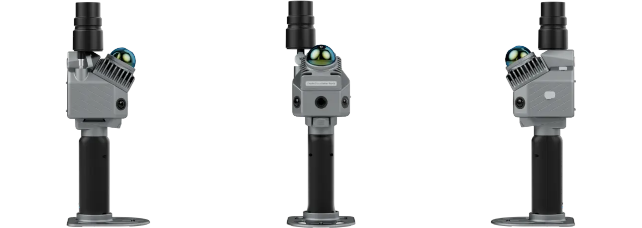
FJD Trion™ P2 LiDAR Scanner

1.2 cm
Accuracy

70m
scanning range

< 1kg
Lightweight and Portable

4-Hour
Runtime

Real-Time
Colorization

Multi-SLAM
Algorithms
Multi-SLAM Fusion, Robust Performance
Eliminate drift with hybrid constraints, even in featureless areas like beaches, tunnels, and parks.
HyperDense+
With the HyperDense+ feature in the FJD Trion Model, it delivers 5-7x denser clouds, giving you better colorization and overall quality.
Real-Time True-Color Point Clouds
One Scan, Multiple Deliverables
Maximize efficiency with multi-format deliverables from a single scan:
Designed to Work Together
Capture, process, and deliver your 3D data within one connected FJD Trion workflow.
Data collection
FJD Trion Scan
App based real time control and scan file management.


Data processing
FJD Trion Model
Generate reports for construction, forestry, mining, and more
Download the Latest VersionGenerate Deliverables
FJD Trion Model for Tablets
On site post processing and preview with iPad and Android support
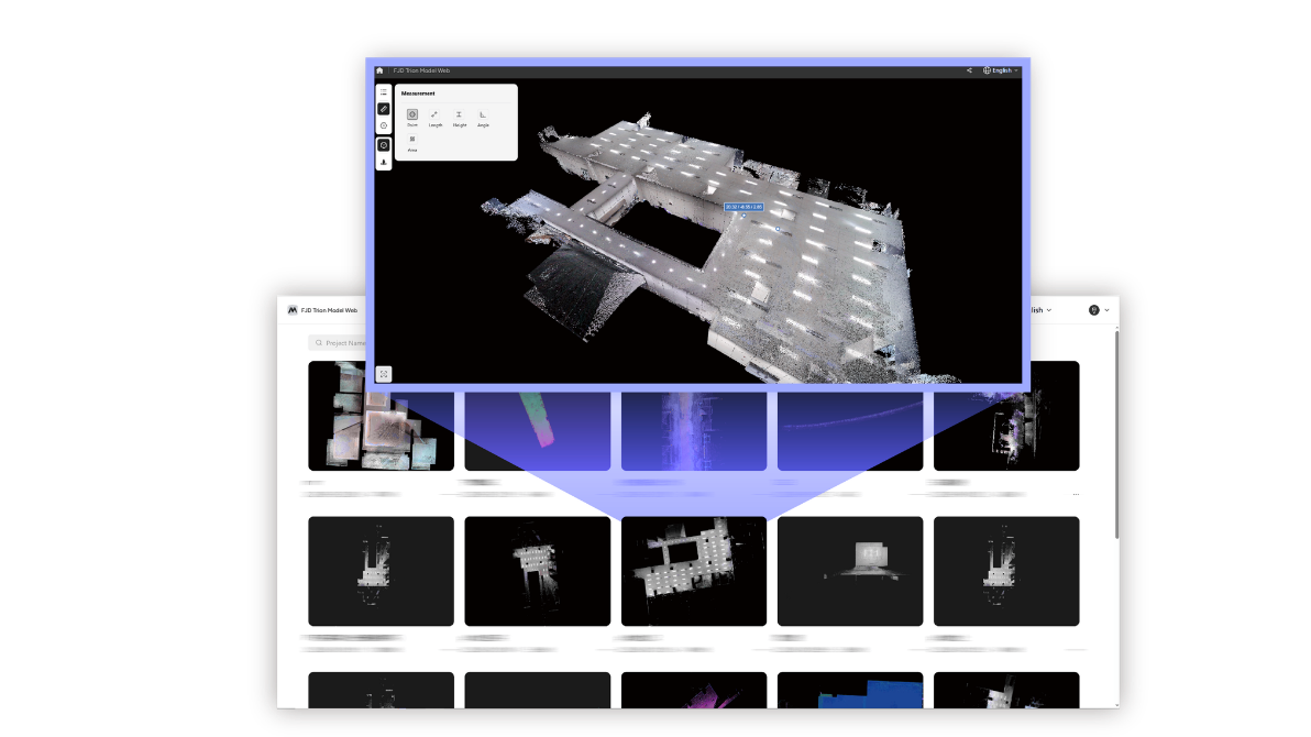
Cloud Collaboration
FJD Trion Model
Share data online and collaborate with your team using different tools
Open Model WebCreate your FJD Trion plan
Our solutions support different field based workflows across construction, forestry, mining, inspection, mapping, public safety, and more. The product combination depends on how your team works today and where time or money is being lost.
If you share your project type, current workflow, and main challenge, our experts can provide you with an FJD Trion solution tailored for your team. Need a free consultation or demo? Contact Us
FJD Trion™ P2 Specifications
LiDAR
40 m @ 10% reflectivity
70 m @ 80% reflectivity
Accuracy
Absolute: 5 cm
Absolute: 3 cm
Build-in Camera
External Camera
Insta360 X5
4K: 3840 x 1920 @ 60 / 50 / 30 / 25 / 24 fps
3K: 3008 x 1504 @ 100 fps5.7K+: 5760 x 2880 @ 30 / 25 / 24 fps
5.7K: 5760 x 2880 @ 60 / 50 / 48 / 30 / 25 / 24 fps
4K: 3840 x 1920 @ 120 / 100 / 60 / 50 / 48 / 30 / 25 / 24 fps18MP (5952 x 2976)
Approx. 18MP (5888 x 2944)
Single-Lens: MP4
System Parameters
(excluding battery, external camera and GNSS module)
1200 g
(including battery and GNSS module)
1500 g
(including battery, external camera and GNSS module)(1TB expandable)
Electrical Specifications
(with 1 set of 2 batteries, including GNSS module, exclude external camera)
3 H
(with 1 set of 2 batteries, including GNSS module and external camera)(exclude external camera)
21 W
(include external camera)GNSS
BDS: B1I / B2I / B3I / B1C / B2a / B2b
GPS: L1 C/A / L1C / L2P (Y) / L2C / L5
GLONASS: G1 / G2 / G3
Galileo: E1 / E5a / E5b / E6
QZSS: L1C/A / L1C / L2C / L5
( IRNSS and SBAS support by a firmware upgrade )
H: 8 mm + 1 ppm RMS
V: 15 mm + 1 ppm RMS
10 Hz
✓
