
1,2 cm Genauigkeit

Echtzeit-Farbgebung

Multi-SLAM-Algorithmen

Georeferenzierte Punktwolke

Anpassung an mehrere Einsatzszenarien

Scannen im Innen- & Außenbereich
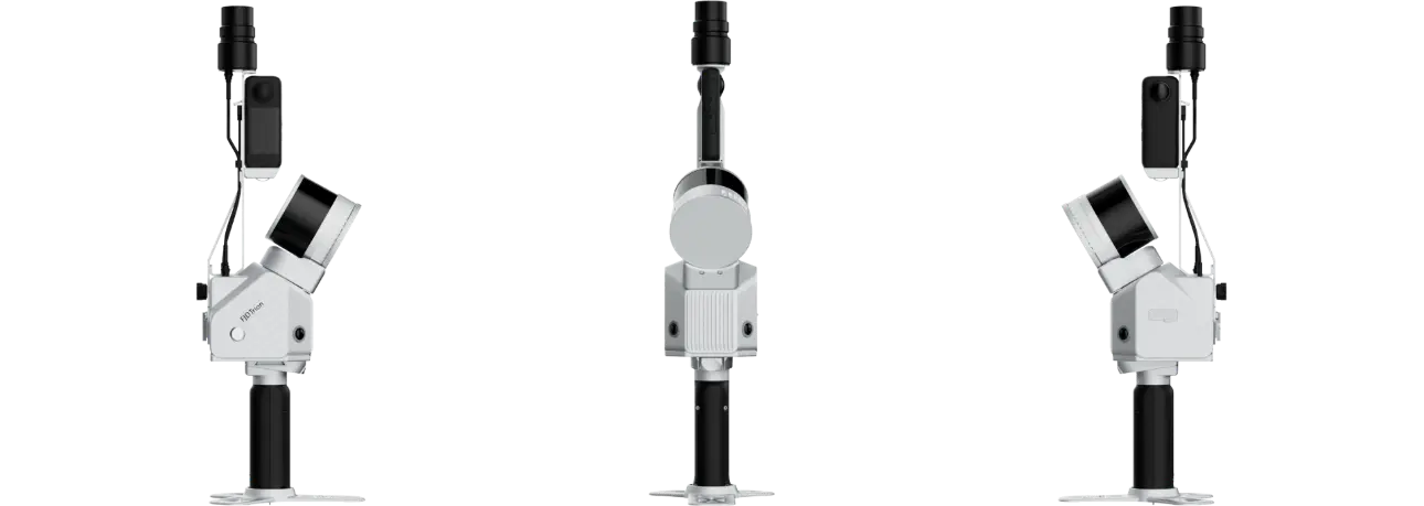
FJD Trion S2 Serie LiDAR-Scanner
Kompaktere Größe, größere Leistungsfähigkeit
Der FJD Trion S2 LiDAR-Scanner verfügt über fortschrittliche VIO- und SLAM-Algorithmen zur Erzeugung hochwertiger und zuverlässiger Punktwolken. Mit Unterstützung für über 8000 Koordinatensysteme macht der S2 zeitaufwendige manuelle Koordinatenumrechnungen überflüssig. Durch die Integration mit der FJD Trion Scan- und Model-Software sowie den Einsatz praktischer Zubehörteile wie Stabilisierungsweste, Drohnenhalterung, Fahrzeughalterung und Roboterhund-Halterung steigert der S2 die Effizienz der Datenerfassung und -verarbeitung bei Vermessungsprojekten im Außenbereich.
Hauptvorteile
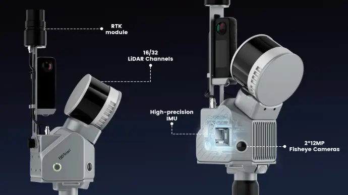
Integration mehrerer Module
Integrieren Sie Kamera-, IMU- und RTK-Module in ein kompaktes Gerät mit einem Gewicht von 2 kg, das Sie für verschiedene Vermessungsprojekte bequem mitnehmen können.
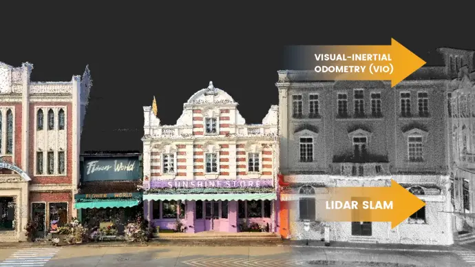
Mehrere SLAM-Algorithmen für präzise Ergebnisse
Zwei 12-MP-Kameras erzeugen hochauflösende Bilder mit fortschrittlicher Visual-Inertial Odometry (VIO) und SLAM-Algorithmen und liefern selbst in komplexen Umgebungen mit wenigen Merkmalspunkten präzise Ergebnisse.
Georeferenzierte Punktwolken
Mit einem integrierten RTK-Modul erhalten Sie direkt unterwegs georeferenzierte Punktwolken. Die Unterstützung von RTK und PPK gewährleistet eine präzise Datenerfassung unter dichtem Blätterdach und in anderen signaltechnisch anspruchsvollen Bereichen. Und mit über 8000 Koordinatensystemen müssen Sie sich nicht länger vor mühsamen Koordinatenumrechnungen fürchten!
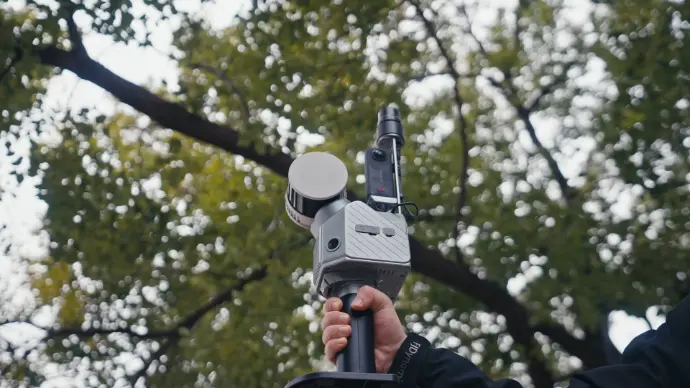
Müheloses Scannen und Tragen
Erfassen Sie Punktwolken in alle Richtungen, selbst in schwer zugänglichen Bereichen, mit praktischem Zubehör wie der Stabilisierungsweste, Verlängerungsstange, Auto- und Drohnenhalterungen, dem Roboterhund und dem Rollkoffer. So können Sie jederzeit und überall einfach losgehen und scannen.
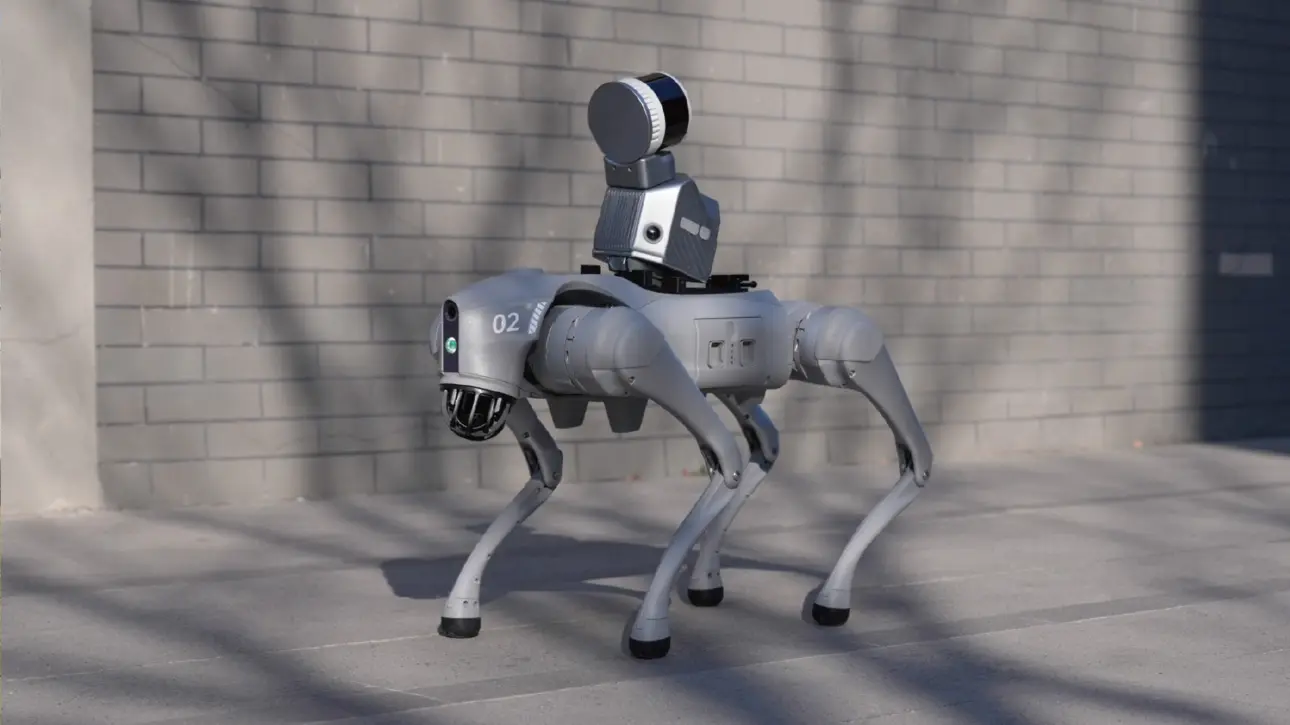
Sicherheit hat Priorität. Die Integration des Roboterhunds verbessert die automatische Navigation und Inspektion in anspruchsvollen Bereichen wie Baustellen, Katastrophengebieten und unterirdischen Anlagen und steigert Sicherheit und Effizienz, indem menschliche Eingriffe minimiert werden.

Schneller scannen in Bewegung! Dieses fahrzeugmontierte Scansystem erfasst während der Fahrt präzise 3D-Daten und ist ideal für großflächige Straßenkartierung, Autobahninspektionen, städtische Straßen, Brücken und Infrastrukturvermessungen.

Stabil auf ganzer Linie! Diese professionelle Stabilisierungsweste hilft Ihnen dank ihres einzigartigen lasttragenden Designs und der ergonomischen Struktur, komfortabler zu scannen, sodass Sie selbst in unebenem Gelände wie steilen Bergen und rauen Oberflächen die Scan-Stabilität beibehalten.
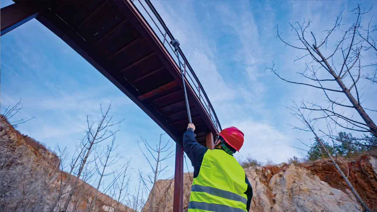
Keine räumlichen Einschränkungen. Die Verlängerungsstange hilft Ihnen, Gebäudefassaden, Brückenunterseiten, dichte Pipeline-Korridore und andere traditionell schwer zugängliche Bereiche mühelos zu vermessen. Mit dem Schnellverschlussmechanismus für Scan-Stabilität erweitert sie den Scanbereich für eine umfassendere Datenerfassung.

Tragen leicht gemacht. Der Rollkoffer entspricht den Standards für den Check-in bei Flugreisen. Seine modularen Aufbewahrungsfächer ermöglichen es Ihnen, den S2-Scanner mühelos zu verstauen und zu transportieren.
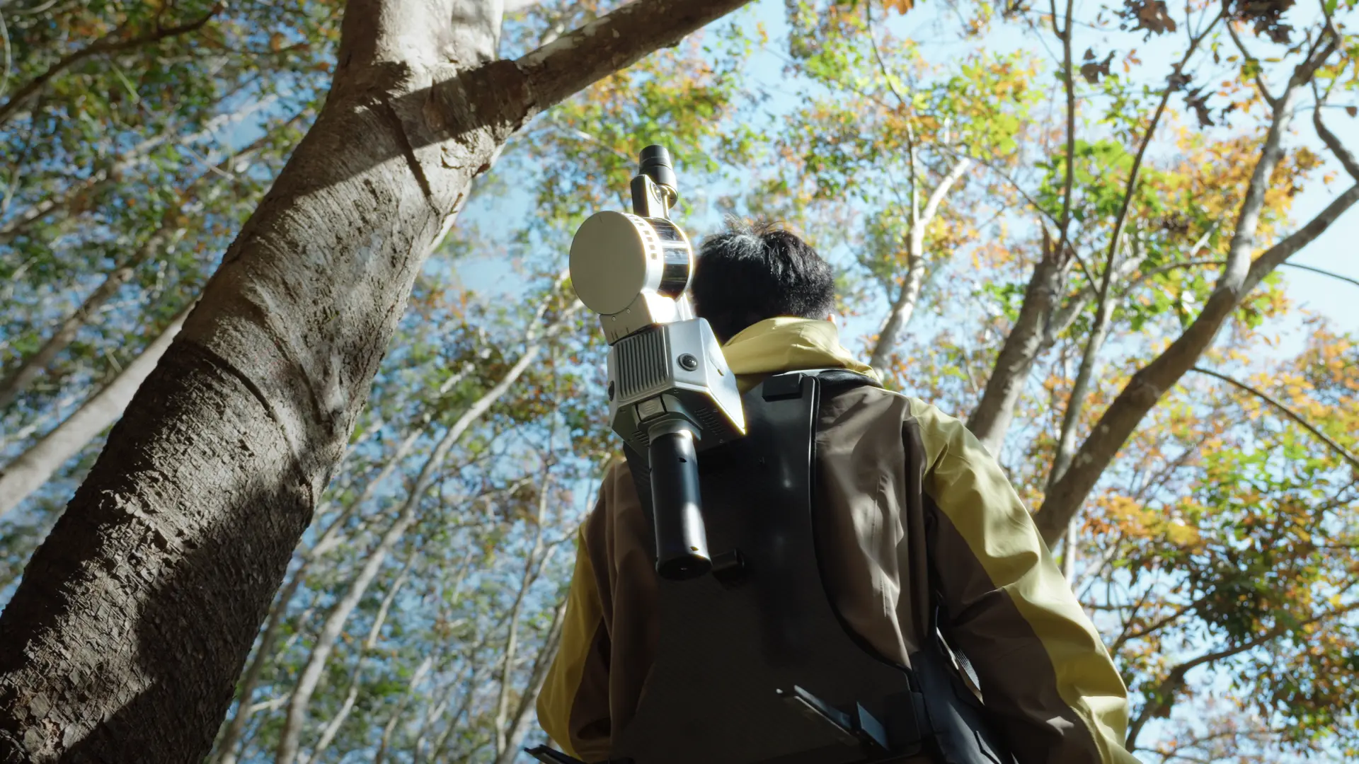
Scannen Sie freihändig und bewältigen Sie jedes Gelände mit Leichtigkeit. Dieser leichte, ergonomisch gestaltete Rucksack ermöglicht einen mühelosen Einsatz in komplexem und unebenem Gelände, reduziert die Belastung des Bedieners und unterstützt längere, ermüdungsfreie Scan-Einsätze.
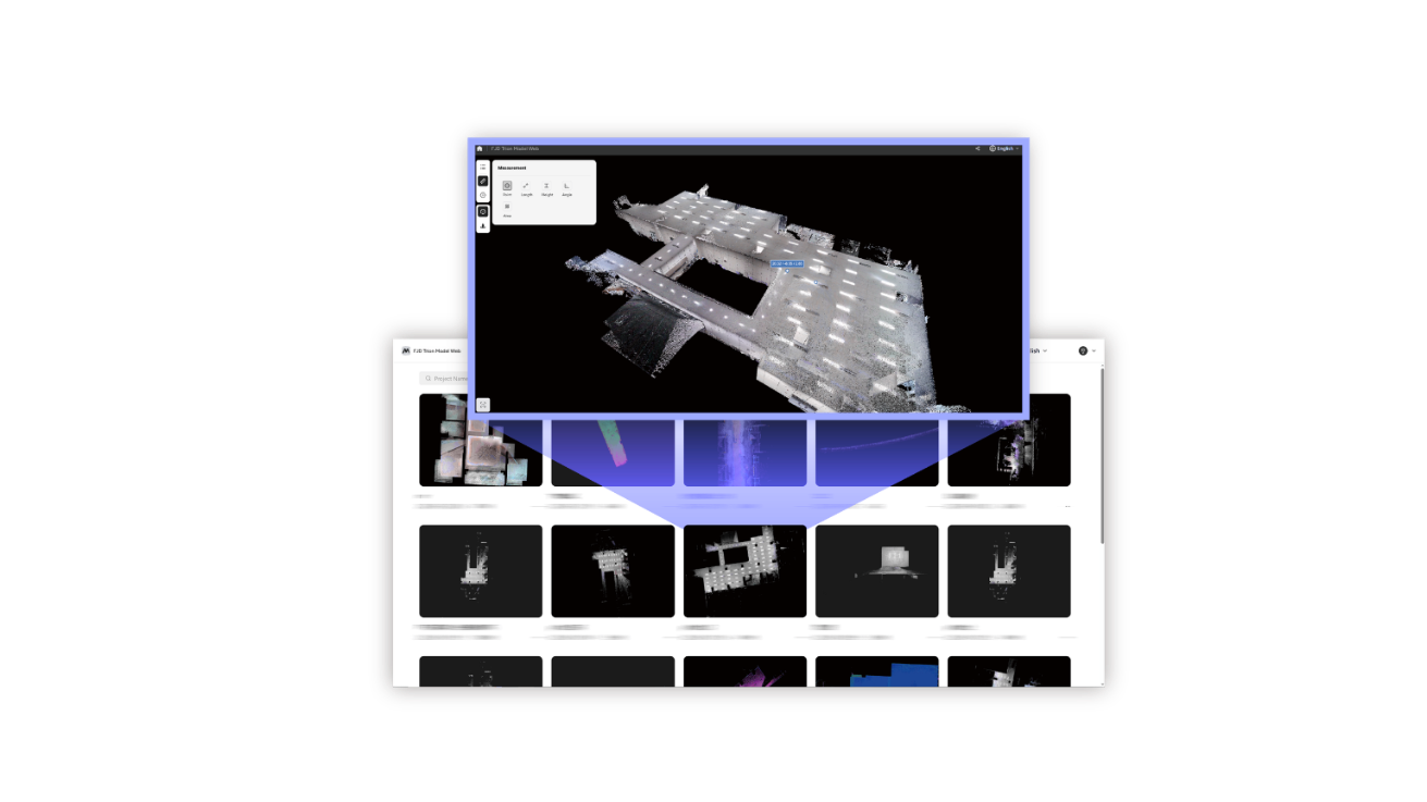
Nahtloser All-in-One-Workflow
Scannen mit Leichtigkeit: erfassen, Vorschau anzeigen und in Echtzeit perfektionieren. Die sofortige farbige Punktwolkenvisualisierung des S2 ermöglicht es Ihnen, die Scanqualität und Abdeckung direkt vor Ort zu überprüfen und so fehlende Bereiche und Nacharbeit zu vermeiden, bevor Sie zusammenpacken.
FJD Trion Model bietet umfassende Funktionen zur Datenverarbeitung. Von der Registrierung von Punktwolken bis zur Modellanalyse automatisiert es den Workflow mit einer Vielzahl von Funktionen, darunter 2D-Kartierung, 3D-Mesh-Modellierung, Gaussian Splatting, Querschnittsanalyse und Berichterstellung. Sie können es sowohl auf PC- als auch auf iPadOS-Plattformen verwenden.
Die Cloud-Plattform macht die Teamzusammenarbeit bequemer und effizienter. Durch die Unterstützung gleichzeitiger Online-Prüfungen synchronisiert diese Plattform Datenänderungen in Echtzeit und sorgt so für transparente Fortschritte.
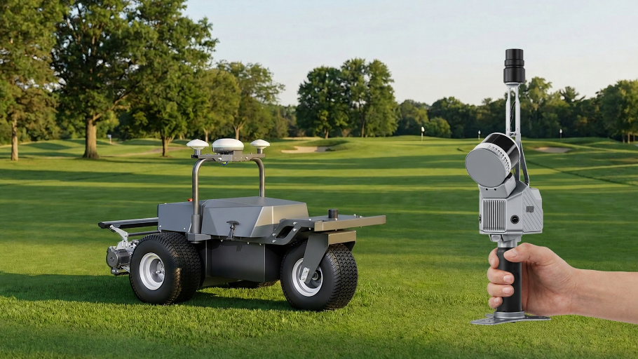
Einmal scannen. Einen ganzen Platz versorgen.
Mit einer erweiterten Scanreichweite von bis zu 300 m ist der FJD Trion S2 Max dafür ausgelegt, weitläufige Golfplätze schneller und mit größerer Abdeckung zu erfassen. Verwandeln Sie den gesamten Platz in ein präzises digitales Asset, um den Einsatz autonomer Mäher, die Routenplanung und ein intelligentes Platzmanagement zu unterstützen.
Entwickelt für perfektes Zusammenspiel
Erfassen, verarbeiten und liefern Sie Ihre 3D-Daten in einem vernetzten FJD Trion-Workflow
Datenerfassung
FJD Trion Scan
App-basierte Echtzeitsteuerung und Verwaltung von Scandateien


Datenverarbeitung
FJD Trion Model
Erstellen Sie Berichte für Bauwesen, Forstwirtschaft, Bergbau und mehr
Das neueste Programm herunterladenErgebnisse erstellen
FJD Trion Model für Tablets
Nachbearbeitung und Vorschau vor Ort mit Unterstützung für iPad und Android
Cloud-Zusammenarbeit
FJD Trion Model Web
Daten online teilen und nahtlos mit Ihrem Team zusammenarbeiten
Kostenlose Testversion startenAnwendungsszenarien

Immobilienverwaltung und -bewertung
Bewerten Sie die strukturelle Integrität, planen Sie Räume und identifizieren Sie Bereiche, die repariert oder renoviert werden müssen. Reduzieren Sie Unsicherheiten bei Investitionsentscheidungen mit Erkenntnissen aus einem umfangreichen räumlichen Datensatz.

Öffentliche Sicherheit
Nutzen Sie Punktwolkendaten, um Katastrophenvorsorge- und Wiederherstellungspläne zu verbessern. Erfassen Sie schnell Beweismittel sowie Tat- oder Unfallorte für eine sofortige und präzise forensische Dokumentation.

Architektur, Ingenieurwesen und Bauwesen
Treffen Sie fundiertere Entscheidungen für Ihre Projekte – vom Entwurf bis zur QA/QC – mit Gebäudeaufmaßen, Scan-to-CAD & BIM, Bestandsdokumentation, Grundrissen und Haldenvolumen.

Topografische Vermessung
Kartieren und analysieren Sie Geländemerkmale präzise mit hochauflösenden Punktwolkendaten. Optimieren Sie Landentwicklungsprojekte, Umweltstudien und die Infrastrukturplanung durch die Erfassung detaillierter Höhenmodelle und Oberflächeneigenschaften.

Bergbau
Verbessern Sie Sicherheit und Effizienz im Bergbau. Nutzen Sie Punktwolkendaten zur Bewertung von Bergbauumgebungen und zur Verbesserung der Genauigkeit untertägiger Kartierungen. Steigern Sie die betriebliche Effizienz durch Echtzeit-Einblicke in Tunnelzustände, Mineralvorkommen und strukturelle Integrität.

Forstwirtschaft und Vegetationsanalyse
Verwalten und überwachen Sie den Baumbestand mit einem kurzen Spaziergang durch den Wald. Messen Sie Baumkronen und analysieren Sie Brusthöhendurchmesser und Baumhöhe mithilfe präziser Punktwolkendaten.
Erstellen Sie Ihren FJD Trion-Plan
Unsere Lösungen unterstützen verschiedene feldbasierte Arbeitsabläufe in den Bereichen Bauwesen, Forstwirtschaft, Bergbau, Inspektion, Kartierung, öffentliche Sicherheit und mehr. Die Produktkombination hängt davon ab, wie Ihr Team heute arbeitet und wo Zeit oder Geld verloren geht.
Wenn Sie uns Ihren Projekttyp, aktuellen Arbeitsablauf und die größte Herausforderung mitteilen, können unsere Experten Ihnen eine auf Ihr Team zugeschnittene FJD Trion-Lösung bereitstellen. Benötigen Sie eine kostenlose Beratung oder Demo? Kontaktieren Sie uns
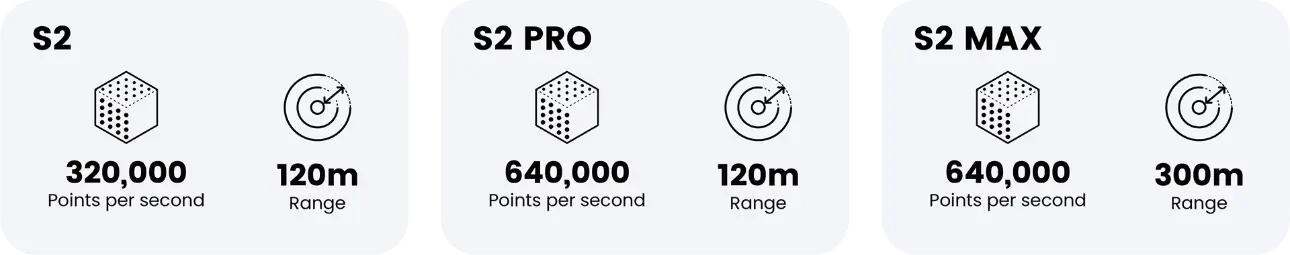
FJD Trion S2 Serie Spezifikationen
LiDAR
80 m bei 10 % Reflektivität
PRO: 120 m bei 80 % Reflektivität
80 m bei 10 % Reflektivität
MAX: 300 m bei 80 % Reflektivität
80 m bei 10 % Reflektivität
PRO: 32
MAX: 32
PRO: 640.000 Punkte/s
MAX: 640.000 Punkte/s
Augensicherheit Klasse I (905 nm)
Systemparameter
3 cm
(Ohne Akku, externe Kamera und GNSS Modul)
(mit 1 Satz aus 2 Batterien)
(auf 1 TB erweiterbar)
Stromverbrauch
180g
(einschließlich Basis und Batterie)
Kamera
GNSS
GPS: L1 C/A / L1C / L2P (Y) / L2C / L5
GLONASS: G1 / G2 / G3
Galileo: E1 / E5a / E5b / E6
QZSS: L1C/A / L1C / L2C / L5
( IRNSS- und SBAS-Unterstützung per Firmware-Upgrade )
V: 15 mm + 1 ppm RMS
